Brightling Down: Rape of Hastings High Point

Brightling Obelisk
Significance: Highest point in the Rape of Hastings
Parent Peak: Crowborough Beacon
Nearest Higher Neighbour: Crowborough Beacon
Present Day County: East Sussex (of which Ditchling Beacon is the County Top)
Elevation: 197m
Date climbed: July 20th 2024
Coordinates: 50° 58' N, 0° 23' E
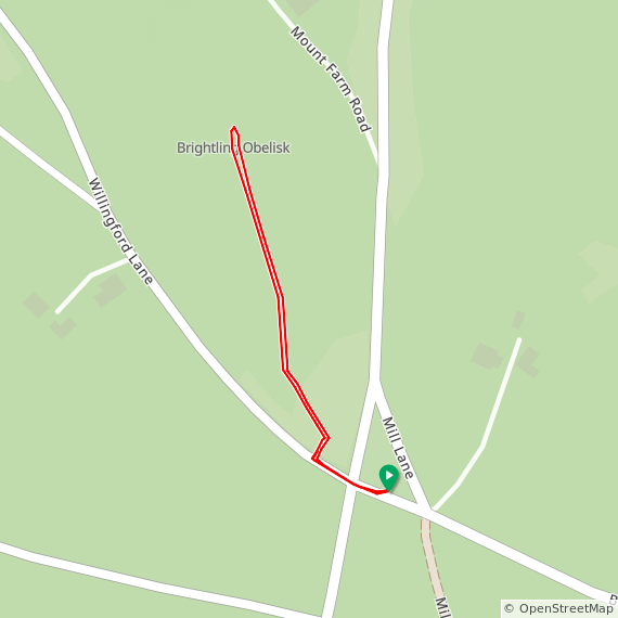
Route Start / End: Small parking spot at junction of Willingford Lane and Mill Lane
Route Distance: 0.6 km (0.4 miles)
Route Elevation Change: +/- 3m
GPX File: get via Buy Me a Coffee
Other routes touched: None
OS Trig Pillar: TP4140 - Jurys Gut (not at the high point, but ~1 km to the south)
Map: Hastings & Bexhill Map | Battle & Robertsbridge | Ordnance Survey | OS Explorer Map 124
Links: Wikipedia (Rape of Hastings, Brightling, Brightling Park), Peakbagger, Hillbagging
The high point of the Rape of Hastings can be found on the edge of the private Brightling Park, currently home to a racehorse training company. The summit is hard to miss as it’s marked by a large obelisk called The Brightling Needle. If you don’t mind a bit of minor trespassing its a 600m out and back walk from a small parking space near the junction of Willingford Lane and Mill Lane.
If you’re no up for tresspassing then don’t hop over the gate into the small wooded area at the south eastern end of Willingford Lane. Don’t follow the track through the woods and hop over another fence into the field, then follow the track up to the Obelisk. Instead, you can see the Obelisk through the fence further down Willingford Lane. Alternatively you can ask permission from the landowner to access the land.
While you’re in the area it’s worth visiting Jury’s Gut, an OS Trig Pillar located 1km to the south on a path next to a kiln-shaped folly called The Sugarloaf.