Walking The Roman London Wall
Start & Finish: Tower Hill Postern Gate, Tower of London, London, EC3N 4DR
Distance: 4.5 km (2.8 miles)
Elevation change: +/- 50m
GPX File: get via Buy Me a Coffee
Other routes touched (walk): Jack The Ripper Walk, Jubilee Walkway, Barbican Highwalks, Green Link Walk, Thames Path (Northern Bank)
Other routes touched (cycle): C3
Pubs / Cafes on route: Everywhere. Many are only open on weekday but you’ll pass many on weekends too. We stopped at Barbie Green (2.5km in)
Map: London North Map | The City, West End, Enfield, Ealing, Harrow & Watford | Ordnance Survey | OS Explorer Map 173
Links: City of London
Beneath the towering skyscrapers and bustling streets lies a 2,000-year-old testament to the city's Roman roots – the London Wall. Built around 200 AD, the London Wall once encircled the Roman city of Londinium, enclosing an area roughly the size of the current City of London. Though much of the wall has been lost to time, several sections remain scattered throughout the city, offering a fascinating glimpse into London's Roman past.
The beauty of the London Wall lies not just in its historical significance but also in its unexpected presence. Sections of the wall peek out from behind modern buildings, offering a surprise encounter with the past as you navigate the city. Keep an eye out for informative plaques along the way, helping you piece together the story of this ancient barrier.
Having walked the City of London Boundary, our next London walk took us along the route of the old London Wall. The whole route is only 4.5km which means you could do it within an hour. There’s so much to see along the way though that I recommend talking it slow and experiencing it over a few hours.
Each section below describes the route between the locations of the old gates. The first 4 sections to Cripplegate have a lot more to see, both remains of the wall and other points of interest.
I’ve noted the blue London Wall information plaques in each section. We didn’t find them all and I assume that some have been lost to redevelopment.
Let me know if you spot any mistakes in the post or if you have any suggestions for improvement. I’ll donate £1 to one of my causes for each update made.


Tower of London to Aldgate
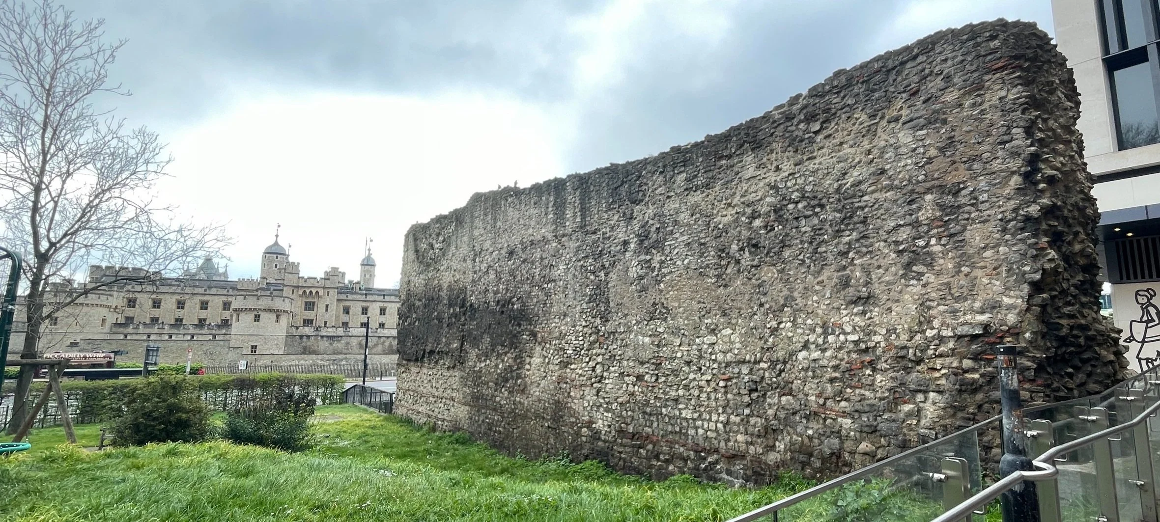
Section Start: Tower Hill Postern Gate, Tower of London, EC3N 4DR
Section Start Coordinates: 51°30'33.7"N 0°04'33.6"W
Section Start Nearest Station: Tower Hill (Circle, District)
Section Distance: ~700m
Section End: Aldgate Old Roman Gate Site, 88-87 Aldgate, EC3A 5DE
London Wall Plaques: 1,2,3,4
Links: Tower Hill Postern, Tower of London, City Wall at Vine Street,
Directions:
From plaque 1 at the Postern Gate walk north to the section of the wall next to Tower Hill Station.
Walk north up Trinity Square and take a right into the courtyard of the Leonardo Royal Hotel London City to find another wall section and plaque 3.
Cross through the hole in the wall and follow the path onto Crescent. Take a left to walk up Crescent, onto America Square, across Crosswalk and onto Vine street. Here you’ll find plaque 4 and the City Wall at Vine Street Exhibition.
Take a left onto India Street then a right onto Jewry Street. Walk north to Aldgate Square to find plaque 5.


Aldgate to Bishopsgate
Section Start: Aldgate Old Roman Gate Site, 88-87 Aldgate, EC3A 5DE
Section Start Coordinates: 51°30'49.0"N 0°04'36.6"W
Section Start Nearest Station: Aldgate (Circle, Metropolitan)
Section Distance: ~450m
Section End: 105 Bishopsgate, London EC2M 3UE
London Wall Plaques: 5, 7. Missing: 6
Links: Aldgate
Directions:
From plaque 5 continue north along the western edge of Aldgate Square onto the A1211 Dukes Road to the junction with the A10.
Plaque 7 is on the wall of Bevis Marks Synagogue.


Bishopsgate to Moorgate
Section Start: 105 Bishopsgate, London EC2M 3UE
Section Start Coordinates: 51°30'57.9"N 0°04'54.1"W
Section Start Nearest Station: Moorgate (Circle, Metropolitan, Hammersmith & City, Northern)
Section Distance: ~520m
Section End: 34 London Wall, London EC2M 5QX
London Wall Plaques: none remain. Missing: 8, 9, 10
Links: Bishopsgate
Directions:
Continue in a north-westerly direction along London Wall until the junction with the A501.


Moorgate to Cripplegate
Section Start: 34 London Wall, London EC2M 5QX
Section Start Coordinates: 51°31'03.1"N 0°05'20.1"W
Section Start Nearest Station: Barbican (Circle, Metropolitan, Hammersmith & City)
Section Distance: ~670m
Section End: St. Giles Cripplegate, Monkwell Square, Barbican, EC2Y 5BN
London Wall Plaques: 11, 13, 14. Missing: 12
Links: Moorgate, St. Giles Cripplegate Church
Directions:
Cross over the A501 to see the Roman Wall Ruins at the junction with Coleman Street.
Cross back over to the north side of London Wall (road) and follow it in a westerly direction to London Wall Place. Here you’ll find the St. Alphage Roman Wall at Salter's Garden.
At the western end of St Alphage Garden, after passing plaque 13, take a right onto Wood Street.
When Wood Street curves to the right to become Fore Street, take a moment to look at the plaque commemorating the site of the first bomb dropped in WW2.
Enter the Barbican Centre and visit St Giles Cripplegate and plaque 14.
Climb the stairs to the Barbican Highwalks heading west to the site of the St Giles Cripplegate City Wall Tower. Descend to the lower level.


Cripplegate to Aldersgate
Section Start: St. Giles Cripplegate, Monkwell Square, Barbican, EC2Y 5BN
Section Start Coordinates: 51°31'06.2"N 0°05'41.5"W
Section Start Nearest Station: Barbican (Circle, Metropolitan, Hammersmith & City)
Section Distance: ~550m
Section End: St Botolph’s-without-Aldersgate, Aldersgate Street, EC1A 4EU
London Wall Plaques: 15, 18, 21. Missing: 16, 17, 19, 20
Links: Cripplegate
Directions:
Walk south, cross over London Wall (road) to see the remains of the wall at Noble Street.
Return to London Wall (road) and take the stairs or lift up to the Highwalks.
Walk east to the Museum of London then south to cross over the road then descend to street level to walk south down St Martin’s Le Grand (road).
Plaque 21 is opposite St Botolph’s-without-Aldersgate.


Aldersgate to Newgate
Section Start: St Botolph’s-without-Aldersgate, Aldersgate Street, EC1A 4EU
Section Start Coordinates: 51°31'00.9"N 0°05'48.7"W
Section Start Nearest Station: St Paul’s (Central)
Section Distance: ~600m
Section End: The Old Bailey, EC4M 7EH
London Wall Plaques: none on this section
Links: Aldersgate
Directions:
Head west through Postman’s Park to Little Britain (road)
Take a right to head south down Little Britain.
Take a right onto the A40, looking out for the plaque for the site of the old Christ’s Hospital on the junction.
Head west to the junction with Old Bailey, the site of Newgate.

Newgate to Ludgate
Section Start: The Old Bailey, London EC4M 7EH
Section Start Coordinates: 51°30'58.1"N 0°06'06.8"W
Section Start Nearest Station: St Paul’s (Central)
Section Distance: ~200m
Section End: 44-46 Ludgate Hill, EC4M 7DE
London Wall Plaques: none on this section
Links: Ludgate
Directions:
Head south down Old Bailey to Ludgate Hill.


Ludgate to Blackfriars
Section Start: 44-46 Ludgate Hill, EC4M 7DE
Section Start Coordinates: 51°30'50.4"N 0°06'09.3"W
Section Start Nearest Station: Blackfriars (Circle, District)
Section Distance: ~450m
Section End: Blackfriars Bridge, Blackfriars Road, SE1 9UD
London Wall Plaques: none on this section
Links: Blackfriars
Directions:
Cross over Ludgate Hill and walk south down Pagemaster Court.
Take a left onto Pilgrim Street then first right onto Ludgate Broadway.
Continue south down Blackfriars Brewery and onto Blackfriars Lane.
Take a right onto Queen Victoria Street then left onto the A201, passing the entrance to Blackfriars Station.
At Blackfriars Bridge take the steps down to the lower level and the end of the walk at the River Thames.
More London Wall Blogs and Videos:
resources that I used in the planning of this walk
More London posts


